Burundi
Burundi, heart of Africa known by its drums, is a landlocked country situated in East Central Africa bordering with Rwanda in North, Democratic Republic of Congo in West, and Tanzania in South-East. The economic capital city is Bujumbura whereas Gitega has recently become a political capital.
Burundi national language is Kirundi whereas French is the official one. The currency of Burundi is the Burundi franc (BIF). The area is 27.834 km2 with a population around 11.5 millions (in 2016).
The major agricultural resources are coffee and tea. The country is rich also of natural resources such as gold, nickel, phosphates, rare earth, vanadium, and peat.
The environment and the countryside are unspoiled, hence making Burundi a desirable tourist destination.
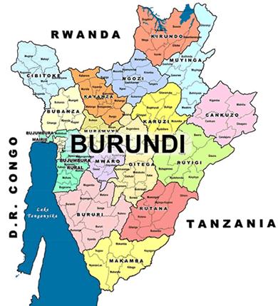
Burundi is divided into 18 provinces and has many exceptional natural attractions that are becoming a key focus of its newborn travel industry and of its tourist resources. Scenic lakes, mountains, wild animals, fairy-tale villages and communities are magnets for prospective eco-tourists.
Brief presentation of Burundi
- Area : 27,834 km2
- Population : 11.5 M UNPF in July 2016
- Capital city : Bujumbura (658859 inhabitants – 2014)
- Lowest point : Lake Tanganyika:772 m longest in the world (677km), second deepest (1400 m), with the largest fish population (200 species endemic to the lake). Connects Burundi to 3 countries (Democratic Republic of Congo , Tanzania, and Zambia).
- Main languages: Kirundi , French , English, Kiswahili
- Climate: Mild. Average 21°C.
Burundi Geography
Burundi’s topography includes the eastern flank of the Western Rift Valley. A chain of mountains and high plateaus formed from ancient Precambrian rock rises to 9,055 feet (2,760 metres) at Mount Heha, the country’s highest point. In the northwest the narrow Imbo valley extends southward from Rwanda to Lake Tanganyika and includes the Rusizi River, which separates Burundi from the Democratic Republic of the Congo. Farther south and west, along the shores of Lake Tanganyika, the land rises steeply to form part of the Congo-Nile divide, which reaches elevations of 8,500 feet (2,600 metres). East of the divide, plateaus slope gently to elevations of 5,000–6,000 feet (1,500–1,800 metres) to the southeast; the Ruvyironza River flows northeast, cutting through the plateaus. A few valleys and shallow lakes occupy the northern frontier near Rwanda.